In June of 2008, the project took on some more
specific searches at the South Carolina Department of Archives
and History (SCDAH). Prior to this, most work at SCDAH had been
limited to their electronic index. This time I would go through
the entire card catalog of maps. About a dozen cards looked interesting.
It would take three trips and two weeks to go through the manual
process of checking-out the items and viewing them. In the end
I had what would prove to be the biggest document finds since
the discovery of the 1844 Lexington County plats. There were three
major finds in all which would rewrite my theories on today's
positions of the McGowan and Stark Ferries and the Confederate
bridge.
So much of my initial enthusiasm and motivation came from the
possibility that these crossings were in my back yard. Within
minutes (a simple measurement and calculation) of the noted position
of the Broad River Bridge on an 1867 Canal Excavation profile
proved that the 1867 bridge remains were not in my back yard.
A magnificent 1870 engineering survey (200' to the inch) of the
canal also agreed exactly with the 1867 profile. Records from
the Broad River Bridge Company showed that the bridge was not
rebuilt until 1870 so I know these surveys point to the position
of the Confederate bridge remains. Both of these surveys were
completed by professional engineers from two different Northern
companies using the best (for that time) of surveying techniques.
I could not argue with these results. The case for the Confederate
bridge was solved. This bridge sat about 200 feet above today's
bridge. I was disappointed in this position but relieved that
the mystery was solved. A physical survey of the area would uncover
the obvious remains of a bridge. My only confusion would now be
with all the evidence that showed McGowan's and Stark's ferries
to be located within 400 yards of the Confederate bridge. The
1825 Mills' Atlas clearly shows McGowan's Ferry off Castle Road
but this is ½ a mile below the new found location of the
bridge (much more than 400 yards).
Enter the 3rd big document find. The 1820 Blackburn/Coate surveys
of Lexington and Richland Districts. These were the baseline for
the Mills' Atlas. I had heard of these but not seen them. Robert
Mill's was a great Architect but were his 1825 Atlas maps an improvement
in accuracy or just recent additions and some cosmetic improvements
over the Blackburn/Coate maps? Upon first inspection, there was
little doubt that the Mill's Atlas was a huge aesthetic improvement
but after taking a few measurements on the Blackburn/Coate maps,
I immediately found that the McGowan and Stark ferries were 2/5
mile higher up the river than what is shown on Mills' Atlas. This
is exactly where they should be located according to the new found
position of the Confederate bridge. What happen in Mills' atlas?
Somehow in the so called "Improved Mill's Atlas", the
1820-1825 Broad River Canal (Bull's Sluice) was 2/5 of a mile
longer in Mill's atlas. The relative position of McGowan's ferry
(just below the end of the canal) was also moved down by 2/5 of
a mile. River Drive takes a strange sharp turn south to connect
with this lower position of McGowan's ferry in the Mill's Atlas.
The 1820 Blackburn/Coate surveys not only show the correct canal
size (proven by an 1806 plat, the 1870 survey, and numerous
other historical documents) but they also show the exact placement
of North Main Street, River Drive, Broad River Road, and Bush
River Road just as they still are today. Mills' atlas is way off
on these road placements. This is impressively shown by doing
a simple overlay of the old Blackburn/Coate maps onto today's
map. The Blackburn/Coate surveys maps are not pretty but they
are as accurate as can be. George Blackburn was a mathematician
and Astronomer and he used extensive Astronomical observations/measurements
on his maps. He is credited with completing the first Longitude
mapping of South Carolina. Robert Mills was a great Architect
and he did a good job in making his Atlas look good but it appears
it was at the price of accuracy. This is very simple to prove
in the Lexington and Richland maps.
Upon finding the correct position of McGowan's ferry, it is
known that Stark's ferry was 400 yards above this. That placed
the Confederate bridge between the two ferries which also agreed
with the 1818 McGowan vs. Stark court case and an 1865 post war
General Assembly petition. I now realized that a previously misunderstood
1846 court case of Huffman vs. The State now made perfect sense
when it placed the bridge in this same manner near the current
bridge site. Suddenly, all the little pieces of evidence, that
would not fit the puzzle before, were quickly falling into place.
Now the position of the two ferries was known. The position of
Stark's ferry fell exactly where the 1870 survey showed a "Broad
River" ferry which also happens to match the relative position
of Sherman's pontoon bridge in William Waud's 1865 drawing of
the Broad River crossing. This made perfect sense. Sherman would
have taken the ferry road to this perfect location for a pontoon
crossing. Now we know the locations for the ferries, Confederate
bridge, and Sherman's pontoon bridge.
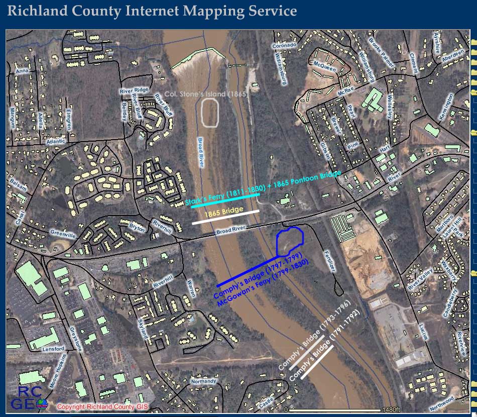
What about the three Compty bridges? The remains of two bridge
abutments are off Castle Road. We know that the third (and final)
Compty Bridge was located at the site of McGowan's ferry. Numerous
General Assembly documents state this as well as the 1818 court
case (McGowan vs. Stark) which also clearly states that McGowan's
ferry never changed position. The abutment at our site (154 Castle)
is about 6 feet higher and much larger than the second abutment
at 150 Castle Road. I believe this indicates that our site holds
the remains of Compty's second bridge. His first bridge was washed
away just after completion in 1792. Certainly, he would have moved
to higher ground. The second site also has an obvious road as
where the first abutment does not. The second site was in operation
from 1793 to 1796 when it was washed away by one of the largest
floods in the State's history. Once again, Compty would move to
higher ground. The third site would be uniquely capable of supporting
a Bridge and Ferry. Compty's final bridge would be completed in
1797. This bridge fell into disrepair in 1799 after the death
of Compty. Compty's widow (Elizabeth) would marry Henry McGowan
and the two started there 30 year operation of McGowan's Ferry.
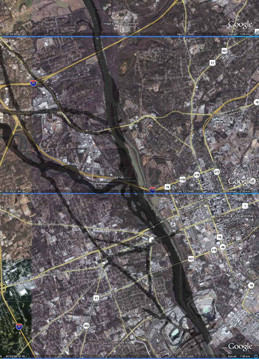
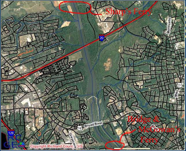
Today's winter aerial photo clearly shows the old east road going
into the old McGowan Ferry site just below today's bridge.
Below is a summary graphic showing the high confidence finds
on today's map.
The easiest way to see where McGowan's ferry
lines up is to do an overlay of an old and new map which are at
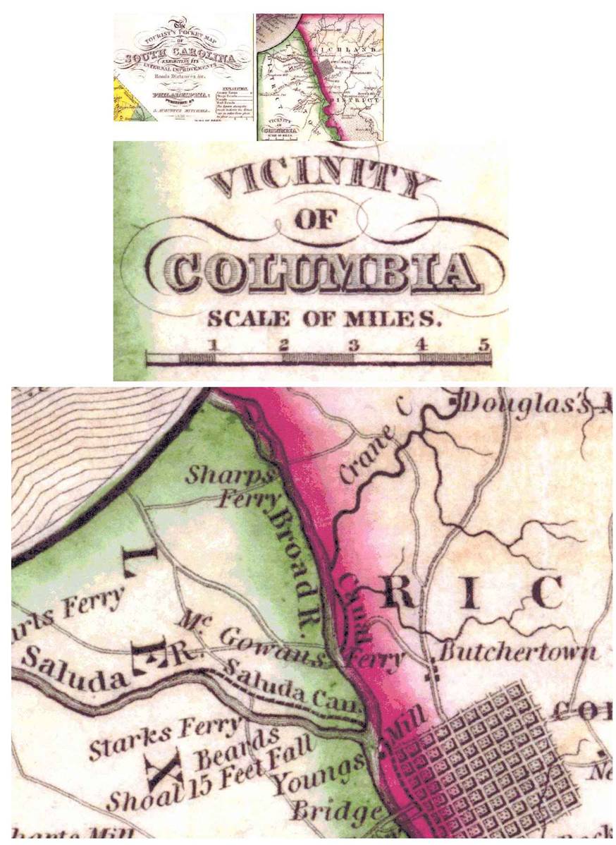
the same scale. The image below is the Mills Atlas of 1825 showing
McGowan's Ferry and a road above this (on the west side) to Stark's
Ferry. Unfortunately, Mill's Atlas introduced an error in the
length of the canal on the Broad River which pushes McGowan's
Ferry down to the Castle Road Site. The overlays below this are
using the Blackburn survey/maps from 1820 which is what the Mill's
Atlas was based on. The Blackburn maps show the McGowan's Ferry
just below today's bridge. This fits with so many other key pieces
of evidence so the Mill's Atlas was eliminated as a reliable source.
Above is the flawed Mills' Atlas of 1825. Below
is the more accurate Blackburn maps of 1820 for Richland and Lexington
Districts with the overlay of each map onto today's map.
Above is the Blackburn 1820 Richland District
Map. Below is the overlay with today's map.
Above is the Blackburn 1820 Lexington District
Map. Below is the overlay with today's map.
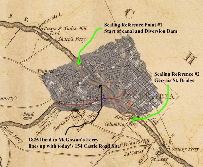
Below is the 1870 Canal Survey overlay onto today's
map showing the Confederate Bridge Position and the Ferry (at
the site of Stark's old Ferry) just above the bridge.
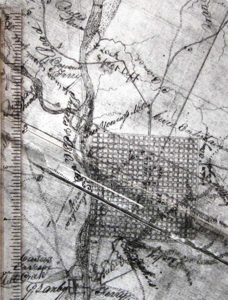
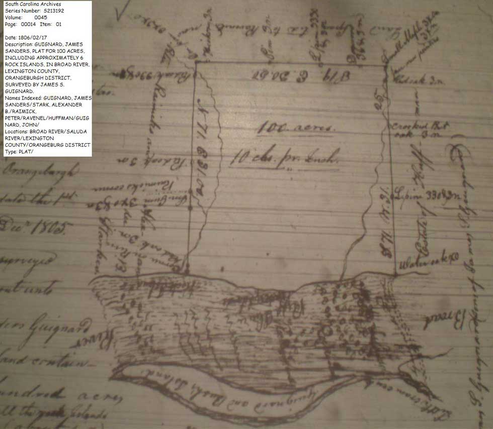
Below is the 1806 plat that shows the length
of Bull Sluice to be only 1/2 a mile. This agrees with the 1870
survey and other historical documents and proves that there is
a significant error in the 1825 Mills' Atlas which shows this
canal to be about 1 mile long causing the position of McGowan's
Ferry to shift down by 2/5 of a mile.
Proof of the Locations of McGowan’s, Stark’s, and Sharp’s Broad
River Ferries
The following evidence provides many relative distances between
McGowan's Ferry and other Ferries on the Broad River.
***
General Assembly Petitions all come from The South Carolina Department
of Archives and History. They can easily be found using their
online index search at http://www.archivesindex.sc.gov/Archives/search/default.asp
. The maps can be found in most libraries and many sources on
the Internet (like the Library Of Congress site: www.loc.gov).
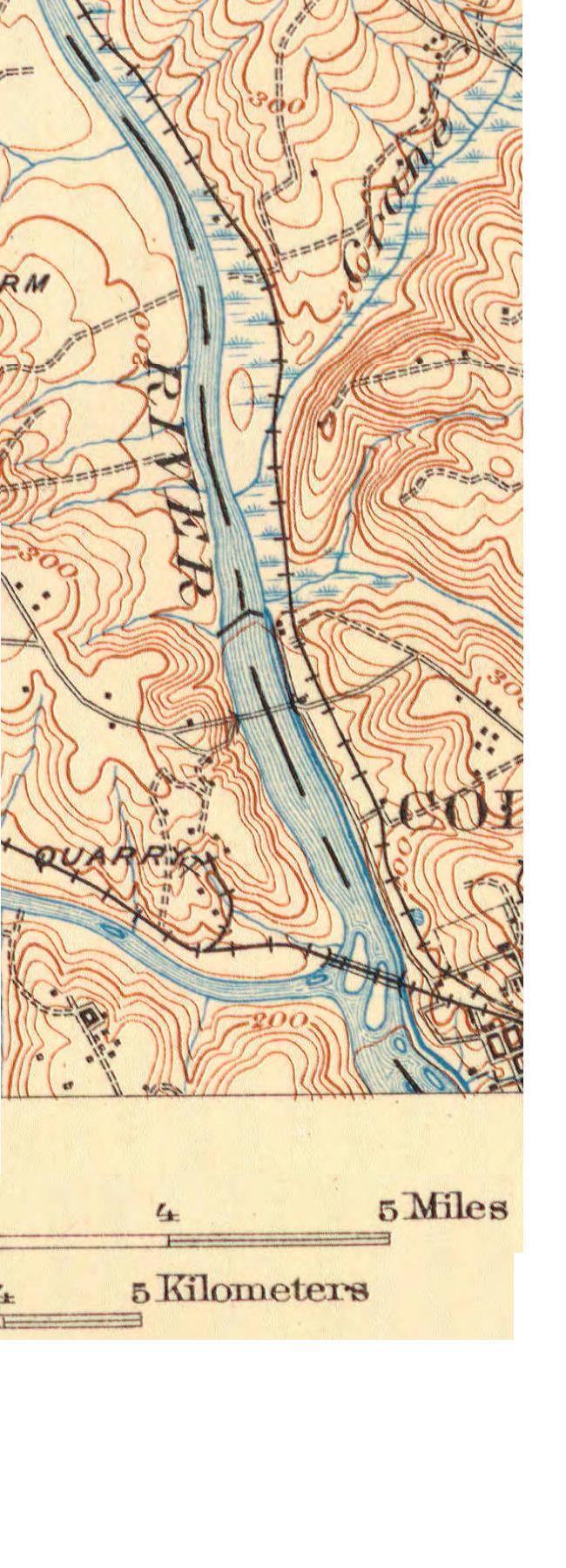
The topology map of Columbia comes from the University of South
Carolina online collection of maps. Today's map images
come from the Richland County online GIS system at: http://www.richlandmaps.com
The
following are petitions to the General Assembly in 1811 (S.C.
Department of Archives and History: Series: S165005 Year - 1811
Item - 00087, Year -1811 Item 107 03) and 1820. They
show that McGowan’s Ferry (also called Compty’s
Ferry) was located one mile above the convergence of the Broad
and Saluda. This places the Ferry on the center
of our property and just above where the bridge remains were found. The below petitions about Sharp’s Ferry show
McGowan’s (Compty’s) Ferry to be three
miles below the proposed Sharp’s Ferry. I was able to locate the
current day position of Sharp’s ferry assuming the position three
miles above our property. Just like our property, there are high
voltage power lines that cross the river at this location. Power
lines have been in place at these sites since the 1890s. At that
time, power lines were always placed along major roads thus proving
that these were crossing points during the 1890s and before. The
drawing included in the Sharp’s 1811 petition shows very accurate
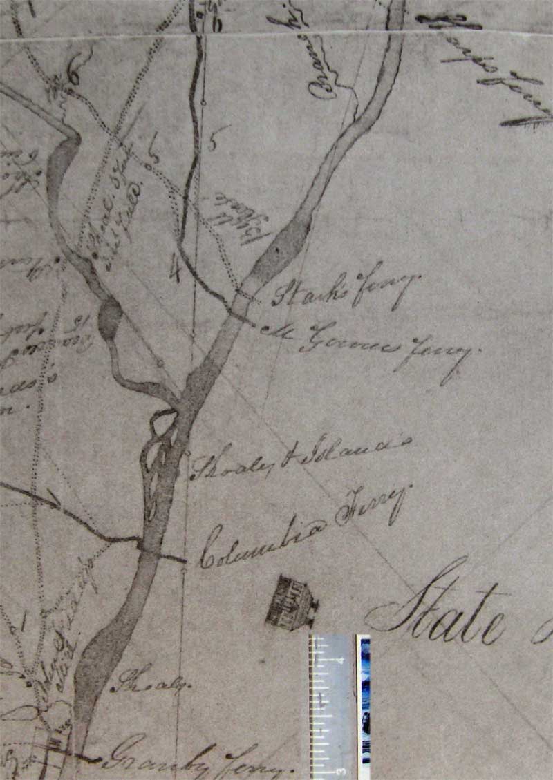
measurements between the Gervais Street Ferry, Granby Ferry, and McGowan’s Ferry. It
shows Stark’s (not Sharp’s) Ferry to be only 200 yards above McGowan’s
Ferry in 1811. Mr. Stark later moved his Ferry a little north
(to 300-400 yards above McGowan’s Ferry) to take advantage of
a better road approach which you can see discussed in the below
petitions done in 1820. One petition points out that the Stark
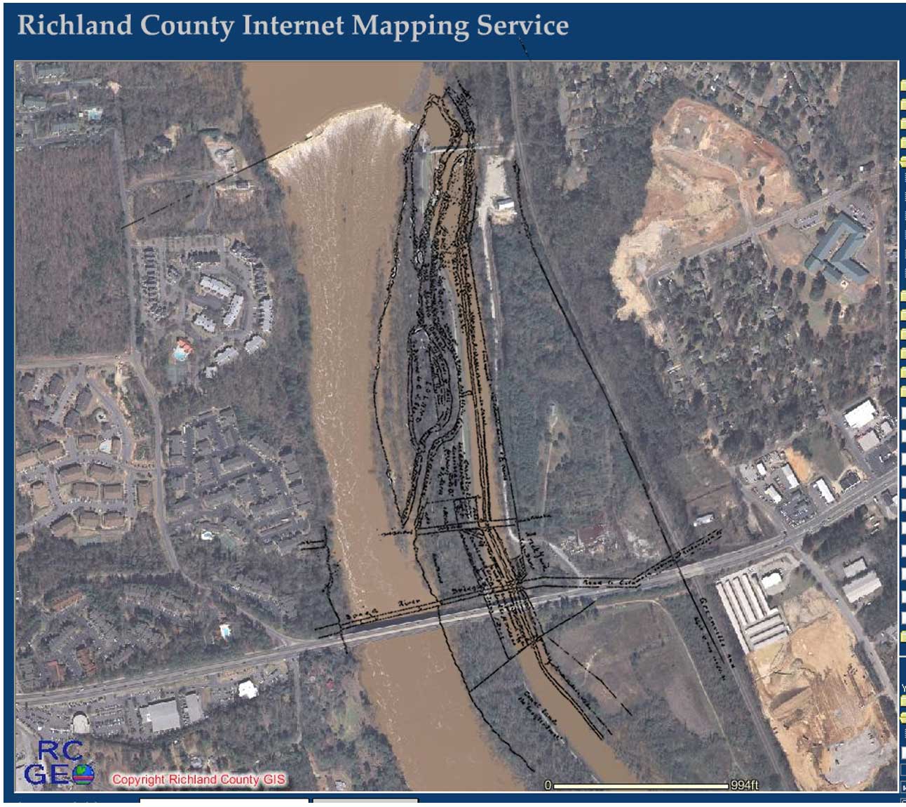
Ferry crossed at a point just above the bottom of Bush’s Island in the Broad River. I have found documents that state
that the Columbia Canal construction took advantage of some
Islands in this portion of the Broad River and, looking at today’s aerial photos,
you can see a very narrow point in the canal embankment just across
from our property which may point to the bottom of the formally
named Bush Island. This would be where Islands were connected to form a canal embankment.
The Civil war drawing of Sherman’s Broad River crossing clearly shows the tip of
Bush island just across from the burned-out
remains of the Broad River Bridge. Many documents state that the first
Broad
River
bridge (1827) was built at the site of McGowan’s Ferry. References
to Bush Island and the Ferries and the Civil war
drawing seem to show that the Civil war bridge
was at the same location as the ferry.
At
the bottom of this page is a Lexington County 1825 map which also
shows very accurate positions of the Columbia (Gervais)
Ferry, Granby Ferry, McGowan’s Ferry, Stark’s Ferry (not labeled
but a road is shown), and Sharp’s Ferry. On this map you will
also see the bottom tip of Bush Island across from McGowan’s Ferry.
Also,
below the Lexington map is a copy of the Mills atlas (same
period) and measurements with today’s maps showing proof to the
positions of McGowan’s and Sharp’s Ferries.
------------------------------------------------------------------------------------------------------------------------------------------------
The
following Petitions were found on Microfilm at the South Carolina
Archives.
S.C.
General Assembly – Petition for Sharp’s Ferry 1811 (S.C.
Department of Archives and History: 1811-108-01):
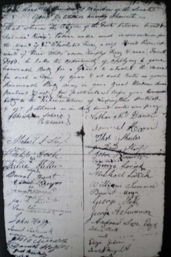
To
the Honorable President and members of the Senate, your petitioner
humbly sheweth.. That where as the citizens
of the fork between Broad & Saluda Rivers labor under much
inconveniences for the want of an established Ferry across Broad
River upwards
of three miles above Compty’s Ferry
& near Fausts Ford, he takes this
opportunity of applying to your honorable Body for a grant to
establish the same for such a term of years & as such rates
as your honorable Body may in your great wisdom deem prudent
? for ? refer your honorable body to the Representatives of Lexington
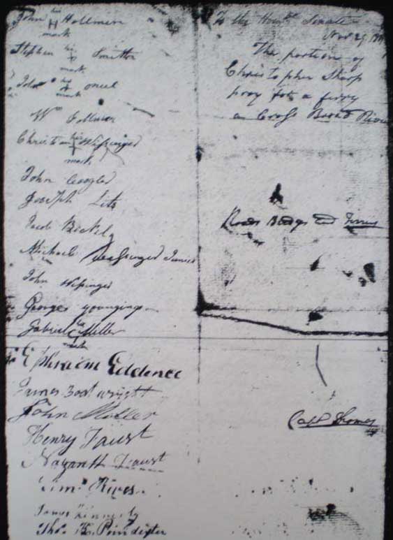
District & your petitioner as in duty bound ? ? ferry. (Signatures follow). See original document below:
(S.C.
Department of Archives and History: 1811-107-01):
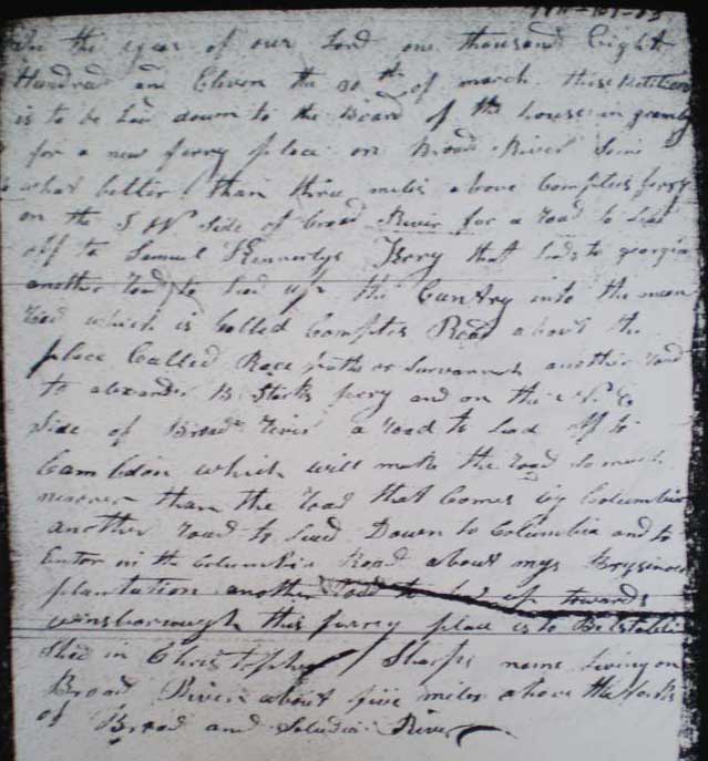
In
the year of our Lord one thousand Eight Hundred and Eleven the
30th of March, this petition is to be laid down to
the Board of the ? ? for a new ferry
place on Broad River some what better than three
miles above Compty’s ferry on
the S.W. side of the Broad River for a road to lead off to Samuel
Kennerly’s Ferry that leads to Georgia
another road to lead up the Country into the ? road which is called Compty’s Road
about the place called Race ? or savannah
another road to Alexander B. Stark’s ferry and on the N.E. side
of Broad River a road to land off to ? which will make the road so much nearer(?) than the road that
comes by Columbia another road to lead down to Columbia and to ? on
the Columbia Road about my Brysinoes plantation,
another road to lead off towards Winnsboro this ferry place is
to be established in Christopher Sharps name living on Broad River about five miles above the forks of
Broad and Saluda Rivers. See original document below:
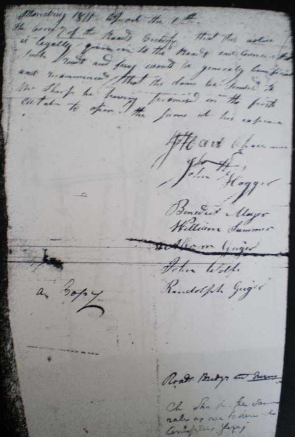
March
1811 – about the 1st
The
coming of the roads certify that this notice is legally given
in to the Roads and conceive that such roads and ferry would be
generally beneficial and recommends that the same be funded to
Mr. Sharp he having promised in the first citation to offer the
same at his expense. Signatures follow. See original document
below:
(S.C. Department
of Archives and History: 1811-107-03):
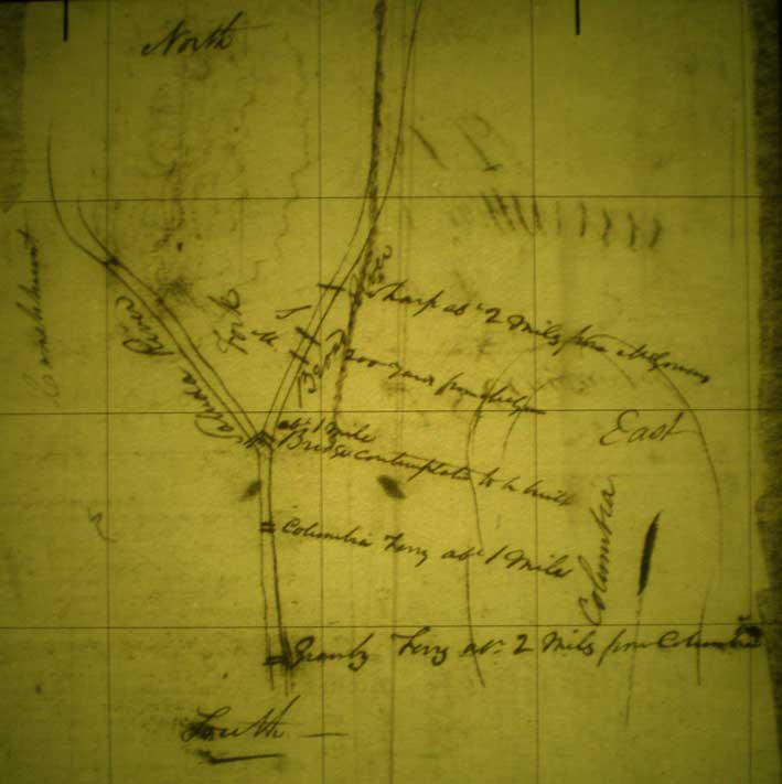
The
above hand drawn map shows a "about" 2 mile distance
between the Columbia Ferry and McGowan's Ferry. This alone does
not pin point McGowan's Ferry because the two possible sites are
a little less than 2 miles and a little more than 2 miles. It
does, however, confirm a general distance and states that Stark's
Ferry was 200 yards above McGowan's Ferry in 1811. Other documents
go along with this and also the fact that Stark's Ferry was, eventually,
moved to about 400 yards above McGowan's.
S.C.
General Assembly – McGowan and Stark Ferry topics (around 1820):
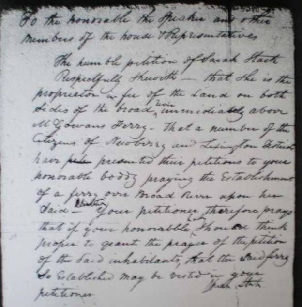
Sarah
Stark: Readable. Summary: Owned land on east and west sides of
Broad River immediately above McGowan’s Ferry.
See original document below (S.C. Department
of Archives and History: Series: S165015 Year -
ND00 Item - 05280):
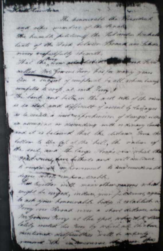
--------------------------------------------------------------------------------------
South Carolina. The honorable the
President and other members of the Senate. The humble petition
of the ? tenants of the Fork between
Broad and Saluda rivers respectfully showeth , that the Ferry now established on Broad River called McGowan’s Ferry has for many
years been the subject of complaint by all whom business compels
to cross at said ferry. The bank and hill on the west side of
the river is so steep and difficult to ascend by carriages as
to create and cast apprehension of danger within ascending and
descending with ordinary loads and it is believed that the distance
from the bottom to the top of the hill, nature of the soil, and
the large rocks over which the road runs have further to and continue
to render its improvement to any considerable degree wholly impractical.
There together with many other reasons
which might be urged, induce your ? again to ask your honorable body to establish a ferry over
Broad river a short distance above McGowan’s ferry
at the spot where A. B. Stark lately erected his ferry by which
all the above mentioned difficulties will be entirely removed.
See original document below (S.C. Department
of Archives and History: Series: S165015 Year -
ND00 Item - 05272)::
--------------------------------------------------------------------------------------
South Carolina. To the Honorable the ? ? ? Senate. The petition of
the inhabitants of Dutch Fork at Humility Sleuth that about three
years ago Mr. Alexander B. Stark set up a ferry across Broad River
about 300 or 400 yards above Mr.
Mcgowan's and made excellent roads to and from the
? and which are no where steep dangerous
or difficult and is yet capable
of further improvements. (rest is too
hard to read). See original document below Series: (S.C.
Department of Archives and History: S165015 Year - ND00
Item - 05271):
--------------------------------------------------------------------------------------
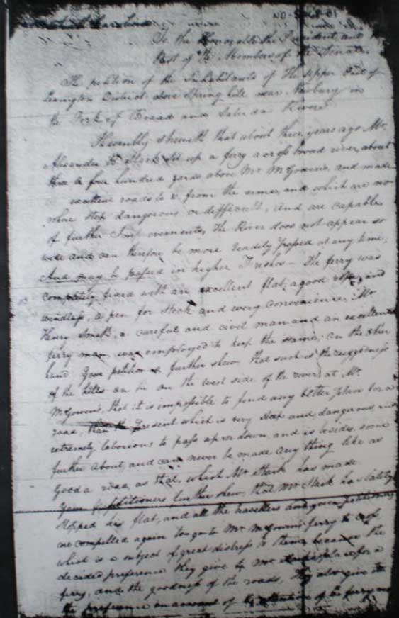
The
petition of ? - Inhabitants of fork Saluda
and Broad Rivers praying for the establishment of a ferry across
Broad River at the lower end of Bush’s
Island at the Plantation of A. B. Stark.
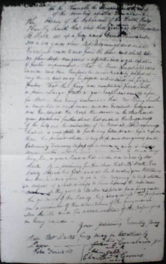
To the Honorable, the Speaker & other Members of the House of Representatives.
The
petition of the inhabitants of that part of Lexington District
which lies between Broad and Saluda Rivers and of the places adjoining
thereto respectfully sheweth to your honorable body. That the bank on the west side of
Broad river at McGowan’s Ferry is so high and
steep which together with its natural
formation
mixed with large rocks and white flint stones as to render it
almost incapable of being reduced to a gradual and safe decent
for the passage of Ladea Wagons. Be by any labor or construction within the powers
of your petitioners. That the inconvenience and hazard of transporting
produce to market across the said ferry is so great as to induce
so many of the citizens of the District to consume great quantities
of produce at home which might be rendered much more profitable
to themselves and to the people generally if a safe and convenient
passage across the said river to a market could be offered. And
many of the more considerable planters whose farms enable them
to raise larger quantities of the various kinds of produce who
are compelled to dispose of a part of their productions in market
are either compelled to encounter the dangers, difficulties and
delays which consistently arise at that ferry, or to be diverted
from their cause a distance of several miles.
Your
petitioners further sheweth that at
a small distance above the said ferry at the place where one Alexander
B. Stark lately erected a ferry across the said river, Nature
has formed a much more eligible situation than ever can be made
at McGowan’s Ferry by the usual and ordinary means of improving
and repairing roads in this State. The roads across the river
at the proposed place are considerable shorter and would render
the transportation of produce to market perfectly safe and convenient.
You
petitioners therefore humbly pray your Honorable body to take
their case into consideration and if it should
? ? to establish a ferry across
Broad River at the place above mentioned.
(Samuel
Huffman is among the signers) See original document below (S.C.
Department of Archives and History: S165015 Year
- ND00 Item - 05270)::
--------------------------------------------------------------------------------------
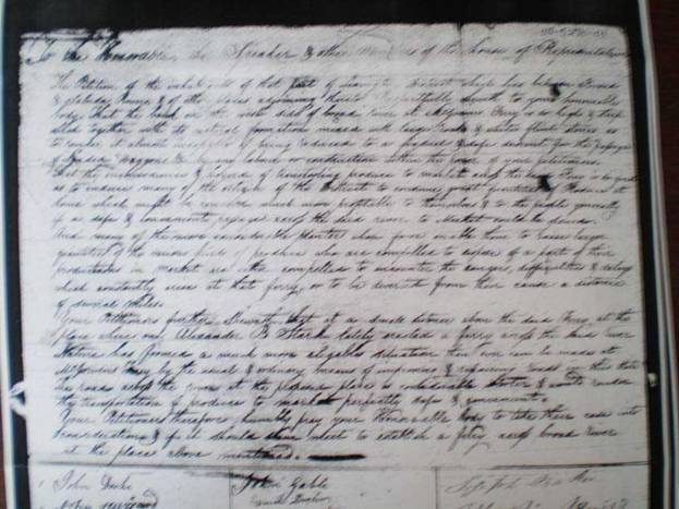
By
Henry McGowan:
To the Honorable President and members of the Senate of South Carolina. The memorial of Henry McGowan sheweth to your honorable body that the present road leading
up from his Ferry landing to the west by being altered a few years
past is made to ascend a very steep hill, greatly to the inconvenience,
delay and trouble of travelers. Your memorialist
further states, that a road taking off to the left of the present
road about fifty yards from the ferry landing leads around the
said hill and comes into the public road about two or three hundred
yards from the ferry. Your memorialist states also that the said road was used by the
public for ten or twelve years until stopped by Alexander B. Stark
immediately after he opened his ferry; and if said road was now
opened by an Act of your honorable body ordering the commissioners
of the roads for Lexington to lay assess and work on the land,
it would be of very great advantage to the public and of no injury
to any individual and your memorialist
in duty bound will ever pray. Henry McGowan. See original document
below (S.C. Department of Archives and History:
Series: S165015 Year - ND00 Item - 01341):
--------------------------------------------------------------------------------------
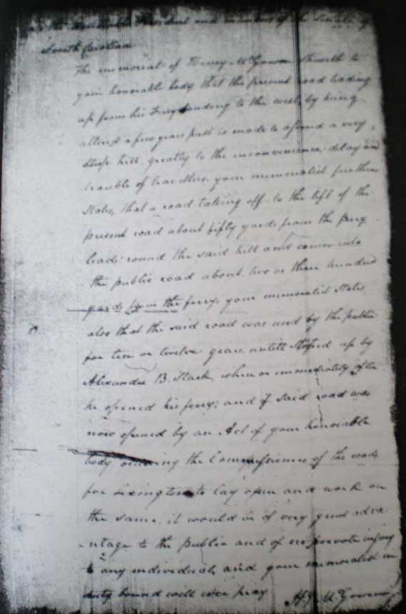
The
petition of the inhabitants of the upper part of Lexington District
above Spring Hills and Newbury in the fork of Broad and Saluda
Rivers.
To the Honorable, the Speaker & other Members of the House of Representatives.
Humbly showith that about three years
ago Mr. Alexander B. Stark set up a ferry across Broad river about
three or four hundred yards above Mr. McGowen’s,
and made excellent roads to and from the same and which are no
where steep, dangerous, or difficult, and capable of further improvements.
The river does not appear so wide and can therefore be more readily
passed at any time and may be passed in higher fleshes – the ferry
was completely fixed with an excellent flat, a good rope, and
windless, a pen for stock and every convenience. Mr. Henry Smith,
a careful and civil man and an excellent ferry man, was employed
to keep the same, on the other hand your petition as further show
that such is the ruggedness of the hills on the west side of the
river at Mr. McGowen’s that it is impossible to find any better place for
a
road than the present which is very steep and dangerous and extremely
laborious to pass up or down and is besides, some further about
and can never be made anything like as good a road as that which
Mr. Stark has made. Your petitioners further show that Mr. Stark
has lately stopped his flat and all the travelers and your petitioners
are compelled again to go to Mr. McGowen’s
ferry to cross which is a subject of great distress to them because
the decided preference they give to Mr. Stark’s place for a ferry
and the goodness of the roads. They also give as the preference
an – of Mr. Stark’s of the ferry ? (rest is not readable). See
original document below: (S.C. Department of
Archives and History: Series: Series: S165015 Year
- ND00 Item - 05268):
--------------------------------------------------------------------------------------
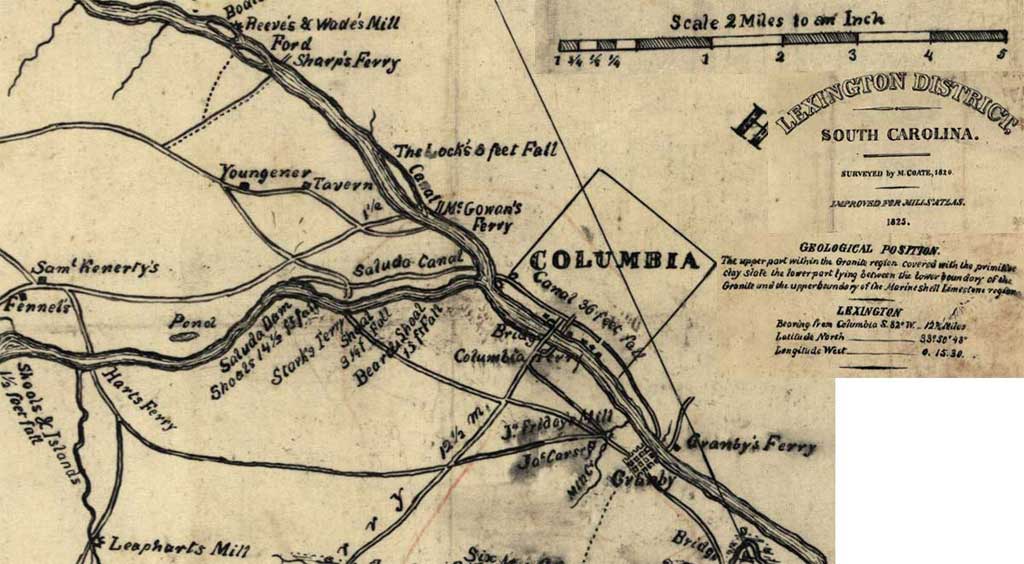
Lexington
County Map – 1825 –
Area of Columbia –
Shows Ferry Positions
Below are 2 more examples of the flawed
"improved" Mills' Atlas where the Broad River Canal
was given an incorrect length of 1 mile. This pushes McGowan's
Ferry too far down the river into the area of Compty's 1796 Bridge
remains on Castle Road.
(Library Of Congress: Lexington District,
South Carolina / surveyed by M. Coate, 1820 ; improved for Mills'
atlas.)
1839 Mills Atlas, 1904
Topology Map, and today’s map.
Today’s map showing the position of Sharp’s Ferry (top) and the 1796 Compty
Bridge Remains (No longer believed to be the site of McGowan’s
Ferry location)
1901/1904 Topology Map which shows old dirt roads to an area close to
the 1796 position of Compty's bridge and another dirt road to
the area of Sharp’s 1811 Ferry
(University of South Carolina online collection of maps)
|